Services
- Details
![]()
![]()

Our company specializes in complete state-of-the-art technology solutions and services within a project’s framework, but can also provide geographic data separately according to customer needs. Specifically, we provide:
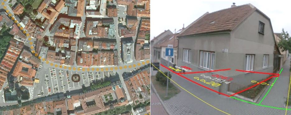
Geographic Data – Satellite Images & Street View
For more information, please read the Leaflet.
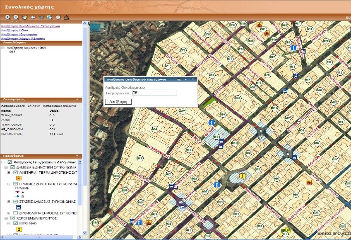
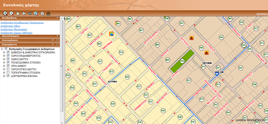
A geoportal is a type of web portal used to find and access geographic information and associated geographic services (display, editing, analysis, etc.) via the Internet. Geoportals can be used for the dissemination of any kind of information in the form of interactive web maps. Our company is developing Web-GIS applications and geoportals for central or local public authorities, as well as for private organizations. In this way they are able to manage and illustrate important geographic information and enhance their digital presence throughout the global web.
Explore the Geoportal of Mykonos Island.
 |
 |
|
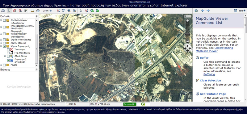
Geoportal for Vrilissia Municipality |
Geoportal for Koropi Municipality |
For more information, please read the Leaflet.
The EU INSPIRE directive, an acronym of the phrase ‘Infrastructure for Spatial Information in Europe’ (European Spatial Information Infrastructure), sets the institutional framework for establishment and operation of the infrastructure for spatial information in Europe, not only to provide information for public services and citizens, but also to implement, coordinate and evaluate EU policies applicable to member countries at all Administrative levels.
Within this framework, our team specializes in development of Spatial Data Infrastructures utilizing the Inspire Directive which is one of the key pillars of innovation for providing advanced services to citizens and businesses. Interoperability and respective geographical data services represents a significant challenge in achieving this goal.
For more information, please read the Leaflet.
Furthermore, Geographic Information Systems (GIS) techniques and Spatial Data Infrastructures can be used:
The integration of geographical and statistical information is one of our objectives that offers important opportunities to maximize the utility of data collected by statistical offices.
Explore an example of an integrated system that combines geographical and statistical information and was developed for the Hellenic Statistical Authority.
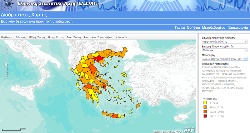
Illustration of statistical data through geoportal for Hellenic Statistical Authority
For more information, please read the Leaflet.
Our company is developing applications for managing public complaints, allowing each operator to manage, supervise and keep records of all complaints made, which receives either from the internal network or from the Internet.
The ability to display complaints real-time facilitates the body in question to follow every complaint throughout the process cycle, from registration and the start of the investigation, the references to and solve it. This application can be fully adapted to the needs of an organization and has the following advantages:
The application can be a powerful management tool for the improvement of functionality and efficiency of the organization.
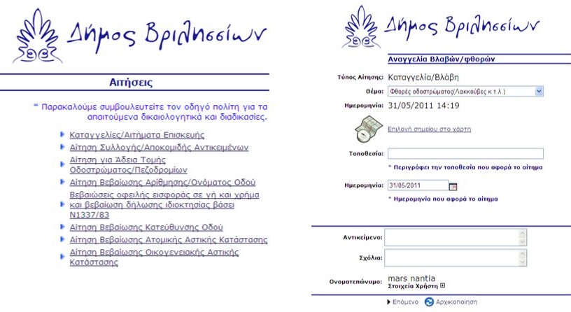
Complaints Management System for Municipality of Vrilissia
The service can be integrated into "e-services" of the Portal of the respective municipality. These services will make use of relevant information to be requested by the user and generated in real time on display on a map and will be presented and geographical information. The user interface in each case will assist the user in the identification of the area or region which has put his complaints (potholes, inadequate lighting, etc.). Also the user will be able to base his request submission number to be informed about the progress of work on this.
Complaints Management System
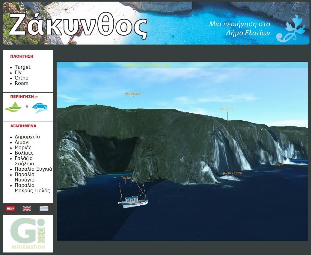
Geographic Information Systems (GIS) have been accepted by more and more spatial data users. The continuous and rapid progress of Web-GIS Technologies combined with the extended use of Internet, provides new opportunities for the stimulation and promotion of Culture and Tourism. Specialized knowledge and appropriate software offer us the ability of three-dimensional representations and the development of Virtual Reality environments combining Digital Terrain Models and Satellite Imagery.
Our Virtual Reality applications can enhance the visual result of a system. Apart from geographical information levels, they utilize three-dimensional object models, animations, etc. and allow navigation in three-dimensional environment with various tools.
 |
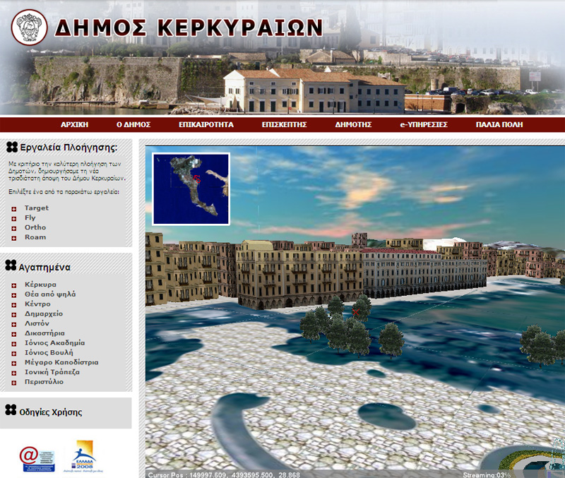 |
| Virtual Reality Routing in Zante | Virtual Reality City Model in Corfu |
Retail analysis aims to analyze the commercial landscape of the city and to propose alternative ways of reinforcing the small and medium scale businesses of the city center. Indicatively, business route planning constitutes a tool that highlights the commercial densities of city center utilizing GIS (Geographical Information Systems) technologies. Within the framework of the analysis, spatial characteristics of central commercial areas are taken into consideration and the final route zone is selected according to certain criteria.
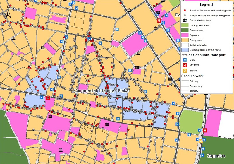
Retail Analysis – Shopping Route Planning
The objective of this study is to design a GIS – based optimal solid waste collection methodology. The study contemplates the redefinition of collection zones, the allocation of collection bins and the determination and routing of the minimum cost/distance optimal collection paths. This study can be elaborated for local public authorities.
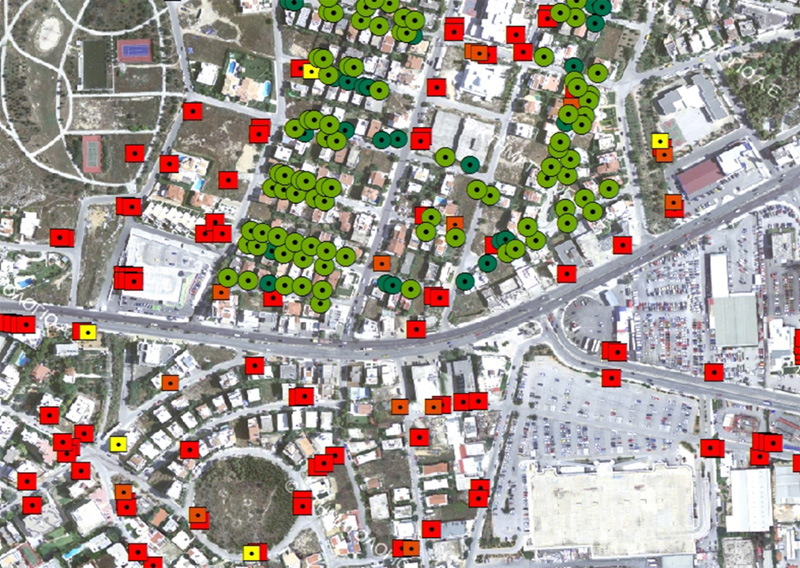
Waste Management Study
For more information, please read the Leaflet.
Our company specializes in complete state-of-the-art technology solutions and services within a project’s framework, but can also provide geographic data separately according to customer needs. Specifically, we provide:
Geographic Data – Satellite Images & Street View
For more information, please read the Leaflet.
A geoportal is a type of web portal used to find and access geographic information and associated geographic services (display, editing, analysis, etc.) via the Internet. Geoportals can be used for the dissemination of any kind of information in the form of interactive web maps. Our company is developing Web-GIS applications and geoportals for central or local public authorities, as well as for private organizations. In this way they are able to manage and illustrate important geographic information and enhance their digital presence throughout the global web.
Explore the Geoportal of Mykonos Island.
|
|
|
Geoportal for Vrilissia Municipality |
Geoportal for Koropi Municipality |
For more information, please read the Leaflet.
The EU INSPIRE directive, an acronym of the phrase ‘Infrastructure for Spatial Information in Europe’ (European Spatial Information Infrastructure), sets the institutional framework for establishment and operation of the infrastructure for spatial information in Europe, not only to provide information for public services and citizens, but also to implement, coordinate and evaluate EU policies applicable to member countries at all Administrative levels.
Within this framework, our team specializes in development of Spatial Data Infrastructures utilizing the Inspire Directive which is one of the key pillars of innovation for providing advanced services to citizens and businesses. Interoperability and respective geographical data services represents a significant challenge in achieving this goal.
For more information, please read the Leaflet.
Furthermore, Geographic Information Systems (GIS) techniques and Spatial Data Infrastructures can be used:
The integration of geographical and statistical information is one of our objectives that offers important opportunities to maximize the utility of data collected by statistical offices.
Explore an example of an integrated system that combines geographical and statistical information and was developed for the Hellenic Statistical Authority.
Illustration of statistical data through geoportal for Hellenic Statistical Authority
For more information, please read the Leaflet.
Our company is developing applications for managing public complaints, allowing each operator to manage, supervise and keep records of all complaints made, which receives either from the internal network or from the Internet.
The ability to display complaints real-time facilitates the body in question to follow every complaint throughout the process cycle, from registration and the start of the investigation, the references to and solve it. This application can be fully adapted to the needs of an organization and has the following advantages:
The application can be a powerful management tool for the improvement of functionality and efficiency of the organization.
Complaints Management System for Municipality of Vrilissia
The service can be integrated into "e-services" of the Portal of the respective municipality. These services will make use of relevant information to be requested by the user and generated in real time on display on a map and will be presented and geographical information. The user interface in each case will assist the user in the identification of the area or region which has put his complaints (potholes, inadequate lighting, etc.). Also the user will be able to base his request submission number to be informed about the progress of work on this.
Complaints Management System
Geographic Information Systems (GIS) have been accepted by more and more spatial data users. The continuous and rapid progress of Web-GIS Technologies combined with the extended use of Internet, provides new opportunities for the stimulation and promotion of Culture and Tourism. Specialized knowledge and appropriate software offer us the ability of three-dimensional representations and the development of Virtual Reality environments combining Digital Terrain Models and Satellite Imagery.
Our Virtual Reality applications can enhance the visual result of a system. Apart from geographical information levels, they utilize three-dimensional object models, animations, etc. and allow navigation in three-dimensional environment with various tools.
|
|
| Virtual Reality Routing in Zante | Virtual Reality City Model in Corfu |
Retail analysis aims to analyze the commercial landscape of the city and to propose alternative ways of reinforcing the small and medium scale businesses of the city center. Indicatively, business route planning constitutes a tool that highlights the commercial densities of city center utilizing GIS (Geographical Information Systems) technologies. Within the framework of the analysis, spatial characteristics of central commercial areas are taken into consideration and the final route zone is selected according to certain criteria.
Retail Analysis – Shopping Route Planning
The objective of this study is to design a GIS – based optimal solid waste collection methodology. The study contemplates the redefinition of collection zones, the allocation of collection bins and the determination and routing of the minimum cost/distance optimal collection paths. This study can be elaborated for local public authorities.
Waste Management Study
For more information, please read the Leaflet.